

MawisPasport – Effective Management and Maintenance of Green Spaces
Get an overview of green spaces and green infrastructure elements. A green space inventory is an important tool for the effective management of public spaces and maintenance planning.
📖 Article in *Moderní obec*: MAWIS: Effective Management and Maintenance of Green Spaces.
In times of drought, water scarcity, and global warming, municipalities are seeking ways to properly care for green spaces and the environment within their financial means. However, solutions do not always have to be complex or costly; sometimes it is simply a matter of being systematic and organized. To care for green spaces properly and effectively, it is essential to maintain accurate records—known as a “passport.” These records provide a detailed overview of individual green space elements and their geographic locations. The inventory is thus a valuable tool for managing municipal assets; when used effectively, it yields significant financial savings in operating costs. Today, the green space inventory is a standard part of local government administration and can be linked to other map data, such as the Digital Technical Map (DTM) or the Cadastral Map.
What are the costs associated with landscaping?
One of the main goals of local government is simply to ensure that residents enjoy a good quality of life in their communities. Beautiful, well-maintained, and safe public spaces—including green areas—contribute to this. However, the costs of maintaining these spaces can sometimes rise quite high, partly due to ad-hoc decisions or “flash campaigns.” So what kinds of costs are incurred for their maintenance? These include, for example, watering, mowing, grazing, harvesting fruit, trash cleanup, weed control, pest control, and the purchase of seedlings, plants, etc. Other costs include issues related to poor maintenance or external factors (frost, etc.), the age of trees, safety, damage to underground utility lines, forced renovations, and so on. All of this constitutes costs that the municipality must bear. However, their amount can be optimized through a tree inventory.
What is a "pasport," and what benefits does it offer municipalities?
An essential part of a municipality’s or city’s development is maintaining records of the existence and condition of its assets. This involves not only a list of assets but also a spatial representation of the elements and their characteristics. Asset inventories thus serve as a key basis for facilitating strategic planning and the organization of maintenance. Some property inventories are required by law, such as the local road inventory or the building inventory (you can also contact us regarding these).
What can we find in the green space inventory?
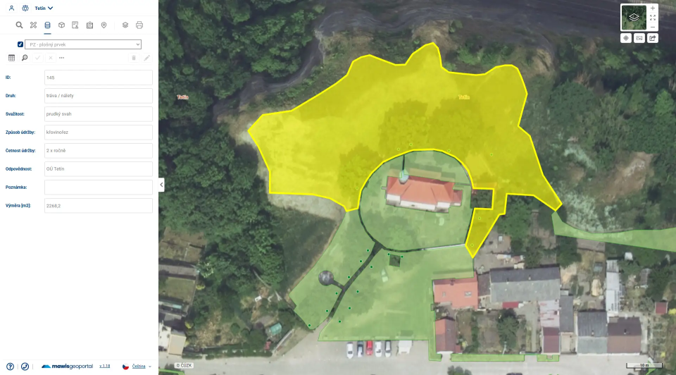
The content of a green space inventory is customized and can be compiled with varying levels of detail depending on specific needs. Generally, a green space inventory may include: trees, shrubs, flower beds, green areas and their extent, dendrology, photographic documentation, a record of defects, planting dates, the condition of vegetation, contractors, etc. These inventories provide a valuable basis for strategic planning, information gathering and verification, and the coordination of planting and maintenance. Some green space inventories also include outdoor furniture, such as benches, trash cans, information boards, etc.
Why does the municipality need a green space inventory?
The extent to which they are used varies from municipality to municipality depending on their needs; both cities and smaller municipalities use green space inventories. As a good steward, a municipality needs to keep track of what it owns so that it can properly maintain it. These inventories, including those of green spaces, serve as tools for the proper management of municipal assets.
Where can the mayor use the passport?
The mayor needs to contract an outside company to mow the grass, a company that bills based on the size of the grassy areas. Because he knows the exact size of the areas, he is able to verify the company’s pricing and performance. At the same time, he can also instruct workers not to mow any planted vegetation or damage the irrigation system.
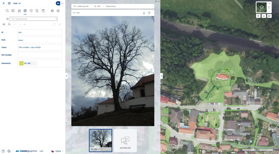
Thanks to the detailed records of all trees on the map and descriptive information (species, age of the tree, date of planting, any defects, the contractor who planted the trees, warranties, photographs, etc.), the mayor has more options for use; for example, he can mark diseased or dead trees directly in the inventory and then have the marked trees cut down or treated.
The Green Passport helps save money by: saving time, fuel, and water; caring for trees and rescuing them in a timely manner; preventing damage through integration with the DTM; and more. It also provides information on ownership relationships.
Why isn't it enough to just have the passports in a table?
It’s one thing to have a cadastral map created, thereby ensuring a comprehensive record. It’s quite another, however, to make even broader use of this data and information in today’s digital world—to streamline work, share it with others, and engage citizens in the process. A cadastre that exists only in a spreadsheet does not provide the context and added value that it can derive from other data, such as other cadastres, digital terrain models (DTMs), and the land registry. By displaying layers “on top of each other,” it’s possible to notice a number of connections at a glance. For example, you might realize that you can’t plant a tree here because a cable runs through that area, and so on. It won’t show where benches or parking spaces are missing.
The property register displayed over the map reveals this at a glance. The ideal solution is to display all property registers, utility networks, and cadastral maps in one place within a GIS environment, such as MawisGeoportal. Because property is displayed in this way in a single location on the map alongside the Digital Technical Map and the cadastral map, the risk of conflicts and losses during construction is reduced, processes are accelerated, and property-related discrepancies can be identified right from the start.
A real-world example
In Mělník, we conducted an extensive update of the green space inventory, focusing on the thousands of trees within the city limits. As part of this project, we surveyed the trees, conducted a detailed assessment of their condition (i.e., dendrology), created photographic documentation, and subsequently entered all the data into MawisGeoportal. Because the inventory is compiled in detail according to the city’s requirements and is also accessible via the MawisGeoportal cloud application, city staff in the field can easily record the current condition using a tablet and directly save and update it in the inventory. In addition, city staff use the green space inventory in the application to assign tasks to technical services, such as “cut down this specific tree (marked on the map) by this date at the latest.” The advantage of this is that they can assign the task directly in the geoportal within the inventory and do not need to send it via email.
Conclusion
So how should you go about creating a green space inventory? Please don’t hesitate to contact us with any questions. We’ll be happy to help you, explain everything, and prepare a green space inventory tailored to your municipality. We have successfully implemented green space inventories in both larger and smaller municipalities and cities.
Would you like to have better tools for your municipality’s land registry?
Contact us—we’ll show you how Mawis can simplify asset management in your municipality.
Miroslava Kubíčková +420 602 477 250 | miroslava.kubickova@hrdlicka.cz
Ladislav Bláha +420 724 863 431 | ladislav.blaha@hrdlicka.cz

More similar articles
New KN Thematic Maps – Easements, Land Categories, and Land Use
Three new thematic map layers from the Cadastral Register (KN) are now available on the Geoportal: easements, land categories, and land use.

Map application to support the construction of linear infrastructure
A mapping platform that consolidates design, construction, and inspection data throughout linear construction projects.
MawisGeoportal as a tool for monitoring construction progress
An application for the construction of highway sections or the renovation of railway lines. It is suitable for linear construction projects, real estate development projects, and smaller construction projects.


