


Frequently Asked Questions
Does MawisGeoportal support communication and the sharing of DTM data with the IS DMVS?
The geoportal is ready to integrate with the IS DMVS. It stores object identifiers from the regional DTM and tracks changes so that it can be used to import updates to the documentation into the IS DMVS in the JVF DTM exchange format.
How can I start using the Mawis Geoportal to manage infrastructure in my organization?
You can launch the demo application right now for a free 30-day trial. The sample project will allow you to see if the pre-configured records and the Geoportal itself can help you manage documentation within your organization.
What are the costs and available packages for using MawisGeoportal?
For information on pricing, deployment options, and collaboration, please fill out the inquiry form or contact a sales representative, who will prepare a customized quote based on your needs. The price of the Geoportal consists of a license fee and the cost of deploying data layers, which depends on the type of data, format, and extent of the lines or areas.
What types of support and services are available to MawisGeoportal users?
The geoportal is provided as part of access to Hrdlička’s broader range of services. Our GIS and CAD data specialists and surveyors are ready to assist you with preparing customized data tailored to your needs, as well as any necessary field surveys.
How can MawisGeoportal help with infrastructure management?
The geoportal will facilitate the sharing of documentation on assets and technical infrastructure networks. When a team uses a web-based mapping application and shares up-to-date documentation, their collaboration on operational tasks becomes more efficient. In addition to map documentation, the geoportal can also contain any other electronic documents related to individual elements.
What is MawisGeoportal, and what is it used for?
Geoportal is a cloud-based mapping application for visualizing, publishing, managing, and sharing geodata and related documents. Geoportal offers a clear and simple way to view and edit geodata, which can be made available to authorized users or published without restrictions to the public. All of this takes place in an online environment where geodata is always up-to-date and immediately available.
Tips and Tricks for MawisUtility
You can find advice and tips on how to use the app HERE.
What is the MawisUtility app used for?
This is an online form designed to facilitate the submission of requests for statements regarding the existence of utility networks. Such requests may also be made for zoning approvals, building permits, and other purposes.
*Our tip: The service does not display the network activity of individual administrators.

I'm having trouble with the MawisPhoto app
The web application is guaranteed to work with Firefox 58.0, Edge 17.17 134, Chrome 64.0.3282, and later versions.
The mobile app is guaranteed to work on the following phone models: Samsung Galaxy A20e (Android 9), Samsung Galaxy A40 (Android 9), and Samsung Galaxy A6 (Android 8). On other devices, the service may not function as expected.
How do I clear my browser's cache?
To ensure that all applications function properly, clear your browser’s history and cache. You can find specific instructions for various browsers HERE.
If you continue to experience problems, please contact the Customer Service Center: 251 618 458, info@mawis.eu.
What is the MawisPhoto app used for?
MawisPhoto allows you to record as-built documentation online. The primary output of MawisPhoto is a textured and realistic 3D model of the actual condition. It is also possible to create 2D raster outputs, which can be integrated into a GIS as WMS, for example. MawisPhoto data is processed using geodetically recognized methods of digital photogrammetry, and the outputs therefore meet Class 3 accuracy standards.
What is the difference between the mobile and web interfaces?
Web application (office) – assigning field tasks, assigning roles, monitoring progress, accessing 3D models
Mobile App (Field) – Creating Documentation in the Field
3D Viewer (Office, Outputs) – Field Data Presented Clearly
What is the difference between a registered account and a public account?
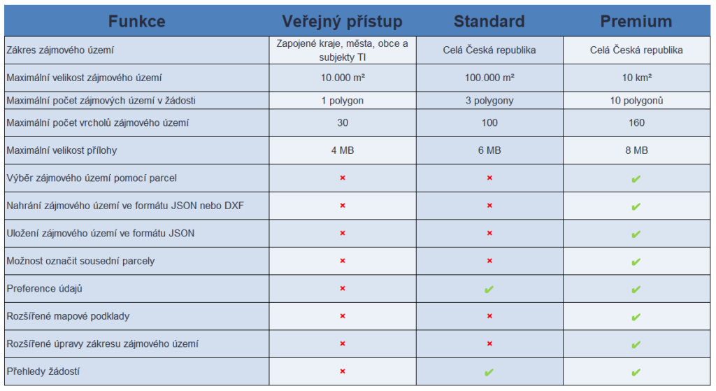
The MawisUtility service offers two options:
Public access -> Use is free only in certain cities or regions. You can find a list of them HERE. This option can be used 3 times per calendar year.
Registered access -> allows you to submit applications throughout the Czech Republic; it is suitable for business owners and offers enhanced features. In the e-shop, you can choose from two options—Standard or Premium. The product is valid for one year from the date of purchase or expires once the purchased submissions have been used up.
Before purchasing the product, you must be registered and logged in to the MAWIS portal.
How do I submit an application?
Select the city or region where you want to submit your application, or log in as a registered user.
To submit an application, you must complete the online form, which consists of four steps.
In the first step, you will enter information about the applicant/investor and the planned project. In the second step, you will map out the area of interest, based on which a list of administrators who may have technical infrastructure in that cadastral area will be displayed on the third page. From the list of administrators, select the ones you want to contact (or those provided to you by the building authority). You will then see additional information, a message from the entity, and the option to upload attachments. In the fourth step, verify your phone number and email address, enter the result of the example, and save your request.
The request will be sent only to those administrators who receive it electronically via the MawisUtility service (by direct entry into the database or via email). A summary of the entire application and a list of administrators who were contacted electronically—as well as those to whom you must submit the application yourself—can be found in the application log, which will be sent to you via email.
*Note: Administrators have 30 days to issue a statement under the law. Our company acts solely as an intermediary and does not issue statements.
*Note: Once submitted electronically, an application cannot be edited or corrected in any way. Once saved, it is immediately sent to TI entities.
*Note: The list of administrators to contact includes only entities that own or operate utility networks (this service cannot be used to contact DOSS).


