



MawisGeoportal – Fall 2024 Updates
Introducing the new features for fall 2024 in the MawisGeoportal app. We’re constantly improving it for you.
Dear Mawis Geoportal users,
We would like to introduce you to the major new features coming this fall in 2024 to our Mawis Geoportal map application. We believe they will make your work easier and improve your experience with Geoportal.
Key updates:
1. Support for the VFK geometric plan format
Graphical data can be uploaded to user layers in the VFK real estate cadastre exchange format.
- The drawing will appear as a new temporary layer on the map
- To save permanently, you must contact the administrator
- In addition to VFK, we also support the DGN, DWG, DXF, VFZE, KML, and SHP formats
2. New thematic maps of the real estate cadastre
Three new thematic maps from the Land Registry have been added to the Land Registry layers:
- Easements with graphical delineation (red polygons)
- Plots by land use (color-coded)
- Plots by land type (color-coded)
3. New Task List Module
The Task Manager module for managing and sharing location-based tasks, which now allows you to:
- Create tasks directly on the map
- Assign them to specific people
- Set priorities and statuses
- Add attachments and comments
- Receive email notifications about changes
4. DTM Network Applications
We have developed a paid DTM network app that displays digital technical map data for regions and offers:
- Access to digital technical maps of regions throughout the Czech Republic
- Detailed specifications regarding technical and transportation infrastructure
- Other useful layers: cadastral maps, flood zones, soil quality, protected areas, and more
5. Integration with Panorama from Mapy.cz
We have added the ability to launch Panorama from Mapy.cz directly within the Geoportal and made minor changes to the map window navigation.
- New button to switch to Panorama from Mapy.cz
- A more intuitive layout of the controls
- Improved map navigation
30-day free trial of the geoportal

More similar articles
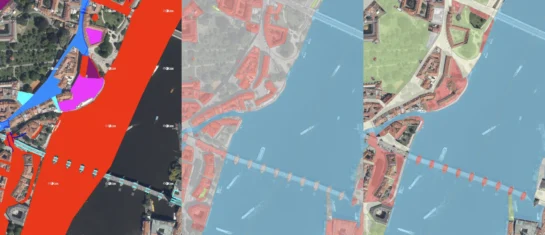
New KN Thematic Maps – Easements, Land Categories, and Land Use
Three new thematic map layers from the Cadastral Register (KN) are now available on the Geoportal: easements, land categories, and land use.

Map application to support the construction of linear infrastructure
A mapping platform that consolidates design, construction, and inspection data throughout linear construction projects.

MawisPasport – Effective Management and Maintenance of Green Spaces
Get an overview of green spaces and green infrastructure elements. A green space inventory is an important tool for the effective management of public spaces and maintenance planning.


