
MawisGeoportal – a new map application
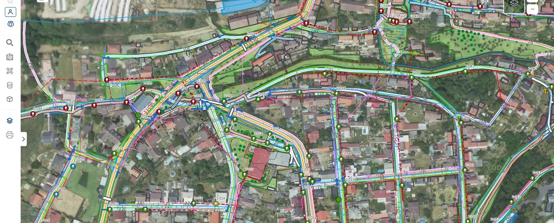
Geoportal is a new cloud-based mapping application for visualizing, publishing, managing, and sharing geodata and related documents.
We are pleased to introduce our latest service, which will transform the way you work with geodata and related documents.
Geoportal is a revolutionary cloud-based mapping application that transforms the way you work with geodata and related documents. Our application is designed to provide you not only with visualization, but also with the ability to publish, manage, and share geodata with unmatched simplicity and efficiency. With Geoportal, you’ll save hours of work and boost your team’s productivity.
With the latest version of the Geoportal, you gain access to advanced features that simplify data management and make it easy to share data with colleagues and partners. Our web application provides lightning-fast access and data visualization right in your web browser, without the need to install any special software. You can easily share project settings, such as displayed layers or the appearance of elements, with others using a generated link.
The Geoportal is designed with flexibility in mind. It allows you to set different permissions and access levels for various users or groups, ensuring that data can be shared with the public without the need to log in, while data administrators have access to advanced features for comprehensive data management. Data editing, geolocation, and integration with the real estate cadastre are just some of the advanced tools offered by the Geoportal.
In addition, the new Geoportal takes sharing and collaboration to a whole new level, with features such as integration with the Network Existence Statement service. This gives infrastructure managers the information they need for effective decision-making right at their fingertips. What’s more, in future updates, we plan to expand functionality, including the ability to share data extracts in CAD format.
At Geoportal, we also take your unique needs into account. We are ready to offer you tailor-made solutions and tools that perfectly match your project’s specifications. Our services include not only data preparation but also subsequent data management, making Geoportal a convenient solution that allows you to focus on what really matters.
Special offer for new clients!
- Try Geoportal for 30 days free of charge and discover how it can streamline your work with geodata.
Don’t get left behind—join the geodata revolution with MAWIS’s Geoportal! For more information, visit our website and discover how Geoportal can make your work easier today!
For more information, visit https://tstwp.mawis.eu/en/sluzby/geoportal/

More similar articles
New KN Thematic Maps – Easements, Land Categories, and Land Use
Three new thematic map layers from the Cadastral Register (KN) are now available on the Geoportal: easements, land categories, and land use.

Map application to support the construction of linear infrastructure
A mapping platform that consolidates design, construction, and inspection data throughout linear construction projects.

MawisPasport – Effective Management and Maintenance of Green Spaces
Get an overview of green spaces and green infrastructure elements. A green space inventory is an important tool for the effective management of public spaces and maintenance planning.


