

Handover without complications—we’ll handle the data entry into the Czech Republic’s Digital Terrain Model (DTM) for you
Are you finalizing the building inspection? We'll take care of entering the data into the DTM ČR and issuing the PGAD and EDTI identifiers for you.
The digitization of the construction industry brings new obligations that no builder can avoid. One of these is the requirement to provide proof, during the final inspection, that data has been entered into the Digital Technical Map of the Czech Republic (DTM ČR). For many companies and investors, however, this remains an unfamiliar or technically challenging area.
When does this apply to you?
Today, you’ll encounter a requirement to enter data into the DTM for every building that has received a final inspection certificate. Typically, these situations include:
- Are you finishing a single-family home or a smaller building?
- You are carrying out a real estate development project
- Are you renovating roads or utility networks?
- Do you manage a facility or technical infrastructure?
- …
The building authority will require you to provide proof that the basic surface layout (ZPS) has been entered into the DTM and that transportation and technical infrastructure (DTI) elements have been recorded in the DTM.
Both of these steps can significantly delay the final inspection.
What if the supplier doesn't provide it?
Not every supplier has the capacity or technical capabilities to work with the Czech Republic’s Digital Terrain Model (DTM). We often find that:
- cannot handle the required format (JVF)
- Software for communicating with the DTM is missing
- The data is not of the required quality
- It is difficult to handle the administrative work involved in registrations and contracts
- The result is a delay in the final inspection and unnecessary stress
How We Can Help You
We provide a comprehensive service for entering data into the DTM ČR—from preparation through final approval.
We'll take care of both tasks for you:
- Processing and insertion of the ZPS/GAD (geodetic update documentation) survey map
- Preparation and inclusion of DTI (technical and transportation infrastructure)
1. Processing and Entering Changes to the Site Plan (ZPS): A Quick and Easy Solution
This is typically performed by a licensed surveyor (AZI) by creating a GAD. After the data is uploaded to the system, you will receive:
- Receipt Form
- Submission ID (PGAD)
If your surveyor does not offer this service, we would be happy to provide it. We need a geodetically verified DSPS survey (as-built documentation) as input.
Estimated prices for creating and uploading a GAD:
- Starting at 3,000 Kč (smaller projects)
- up to approximately 8,000 CZK (larger projects)
2. Processing and Submitting DTI Changes: A More Complex Process
Data cannot simply be uploaded as a file—you must use web services and meet several requirements:
- Registration of the Infrastructure Owner in the IS DMVS
- Role settings (owner – administrator – operator – contributor – editor – founder)
- Establishment of a contractual relationship (owner × publisher)
- Conversion of data to the JVF standard format
- Addition of elevation data
- Generating buffer zones
- Definition of DTI scopes (= which data groups I manage—based on the JVF DTM data model classification)
- Definition of DTI segments (= delineation of the area where data from a given group occur)
Once the submission is successful, you will receive a Change Identifier (EDTI), which serves as proof for the authorities. As input, we need a geodetically verified DSPS survey (as-built documentation).
Estimated prices for creating and uploading a DTI:
We evaluate each project on a case-by-case basis, but as a general guideline:
- 6,000 CZK – flat fee for transferring data to JVF DTM and adding required attributes
- 1,200 Kč – for each kilometer of network or part thereof
- 6,000 CZK – entry into the IS DMVS
A long-term partnership involving the use of an external editor results in lower costs.
How quickly can we get this done?
- Standard delivery within 14 days
- Express processing available upon request
Speed and cost always depend on the quality, scope, and readiness of the source materials.
https://www.dtmcr.cz – Information about DTM ČR and our services
Contact Us
Get in touch, and we'll create a customized solution for you. You can reach us by phone or email.
Ladislav Bláha | +420 724 863 431 | ladislav.blaha@hrdlicka.cz


How do I obtain a record identifier in the Digital Technical Map?
It is now mandatory to provide the Digital Technical Map record identifier when applying for a building occupancy permit. We can help you with this.
Digital Technical Map and MAWIS Services – Potential for Construction, Management, and Maintenance
MAWIS's digital services, in conjunction with the Digital Technical Map, support the construction process in the Czech Republic.

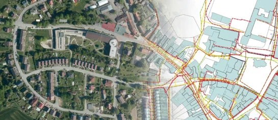
DTM ČR – A New Tool for Infrastructure Management and Planning
DTM consolidates previously fragmented data into a single digital model that can be used by both the public and private sectors.


