aktuality_do_mailuarrow-backarrow-bottomauthorbasketbezbarierove_mestoblockquotebtn-arrow-backbtn-arrowcalendarcheckcheckedclosedigitalni_evidencedopravni_znaceniemailfacebookfaqfb-circlefooter-imghousehrbitovinfointuitivni_ovladanikatastralni_datalarge-arrow-bottomlinklinkedin-sidebarlinkedinlist-arrowlockloginmapamistni_komunikacemobiliar_obcemobilni_aplikacemodul_DTMmunicipalitynastaveni_roli_a_spolupracenavrhy_na_vkladnewsletterochrana_obyvatelodeslaniphonepozemkove_upravypresnostprojektantiregcountsearchservice1service2service3service4silne_zabezpeceni_a_dostupnostsmlouvy_na_klikspoluprace_nad_dokumentacispravcistavebnicisubjektysupporttechnicka_infrastrukturatriangle-bottomtrideny_odpadtwitterutilityuzemni_planverejne_osvetleniwebova_aplikaceworkerxingyoutubezadatelzelenzivotni_cyklus_stavbyzivotni_situacezrychleni_vystavby

MawisPasport
Inventory of Municipal Assets

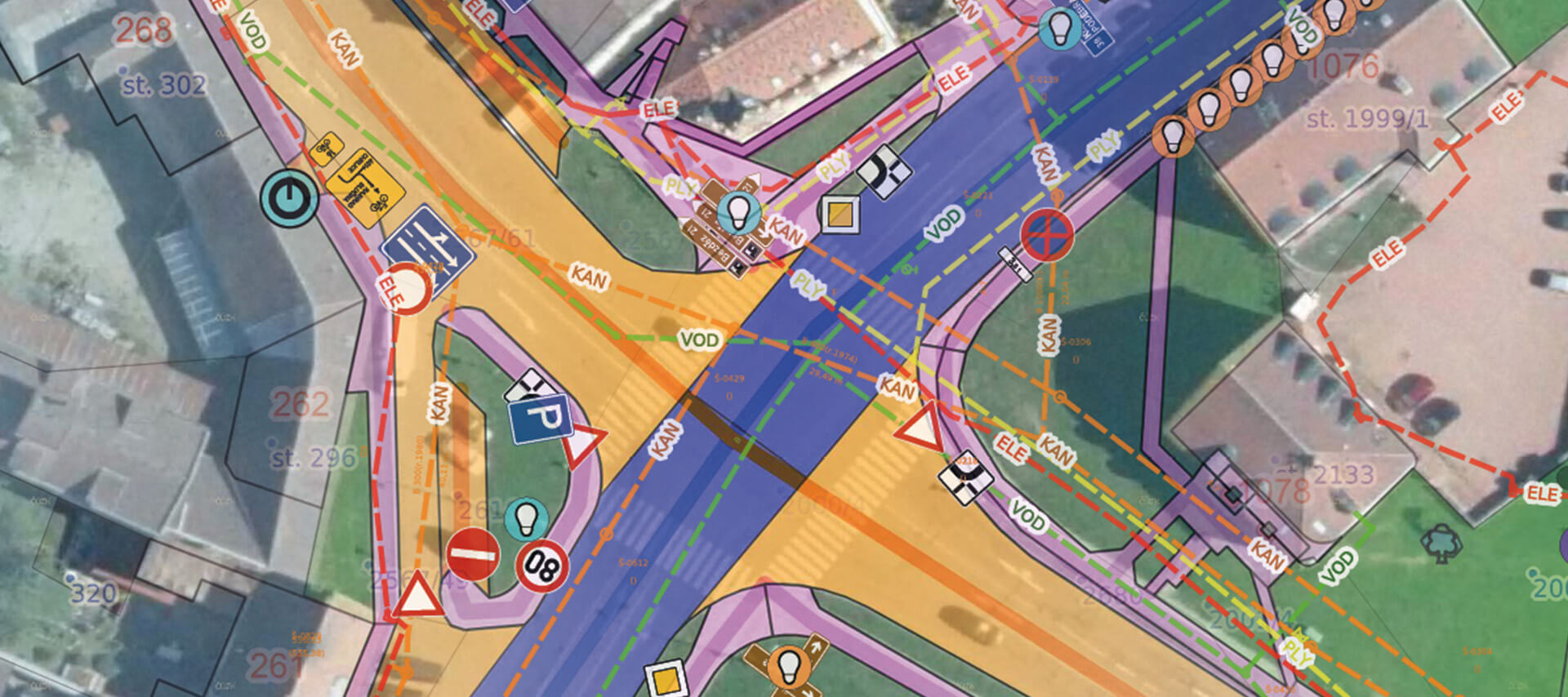
Asset inventory refers to the recording of tangible and intangible assets in a comprehensive database. The inventory provides an overview of the municipality’s assets, including additional information on their technical condition that is necessary for asset management. The assets in the inventory are geolocated and, if necessary, can be surveyed with an accuracy corresponding to the Czech Digital Terrain Model (DTM ČR).

Why keep an asset register, and what is it?

Benefits of Obtaining Passports

  • A comprehensive overview of municipal property in one place
  • Simplifying asset management
  • Resolution of Property Disputes
  • Cost savings on maintenance, e.g., of green spaces
  • Record of the actual condition
  • Basis for audits (energy audits, etc.)
  • Guidelines for Grant Applications
  • What does a passport generally look like?

  • The individual elements are geolocated (shown on the map)
  • Visualization of map features based on user-selected attributes
  • Each element contains descriptive information
  • Each item may contain photos and other documents (inspection reports, etc.)
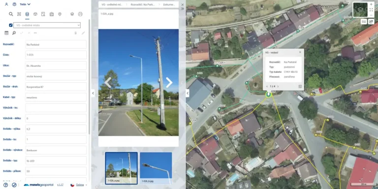
  • How is passport data generated?

  • Surveying
  • 3D laser scanning – street surveys using a mobile scanner,
  • Mapping with a static scanner
  • Drone mapping
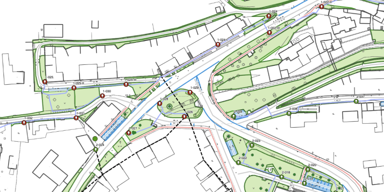
  • How are the Cadastral Maps and the Digital Technical Map related?

  • Network inventories (street lighting, sewer systems, water supply, roads) serve as the basis for entering network data into the Digital Terrain Model (DTM). This is a legal obligation of the network owner under Act No. 47/2020 Coll.
  • Additional information on network elements is maintained outside the scope of the central DTM of the Czech Republic but in accordance with it
  • The municipality's networks are displayed on the map alongside those of other owners (EGD, CETIN, Gasnet, etc.)
  • The integration with the DTM serves as a primary source of information for land-use planning, site selection, and building permits, as well as the protection of public interests
  • For more information about the DTM, visit the Digital Technical Map page.

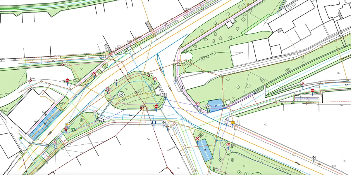
    Maps in the map app Mawis Geoportal

  • Online overview of municipal assets over a map
  • You can easily add, edit, and modify descriptive information
  • You can attach a wide variety of document types (jpg, pdf, doc, xls, and many others)
  • For efficient management, you can share tasks, notes, and map compositions with others
  • Your data is overlaid on DTM and cadastral data, which makes decision-making easier
  • Your data is securely stored in the cloud, and we take care of it
  • Users always work with a single dataset, which means it is always up to date
  • You'll never lose any data or information again—everything is stored in MawisGeoportal
  • Available property records

    I can help you with your property inventories

    Miroslava Kubíčková

    Technical Consultant for the MAWIS Portal

    Oops! We could not locate your form.