aktuality_do_mailuarrow-backarrow-bottomauthorbasketbezbarierove_mestoblockquotebtn-arrow-backbtn-arrowcalendarcheckcheckedclosedigitalni_evidencedopravni_znaceniemailfacebookfaqfb-circlefooter-imghousehrbitovinfointuitivni_ovladanikatastralni_datalarge-arrow-bottomlinklinkedin-sidebarlinkedinlist-arrowlockloginmapamistni_komunikacemobiliar_obcemobilni_aplikacemodul_DTMmunicipalitynastaveni_roli_a_spolupracenavrhy_na_vkladnewsletterochrana_obyvatelodeslaniphonepozemkove_upravypresnostprojektantiregcountsearchservice1service2service3service4silne_zabezpeceni_a_dostupnostsmlouvy_na_klikspoluprace_nad_dokumentacispravcistavebnicisubjektysupporttechnicka_infrastrukturatriangle-bottomtrideny_odpadtwitterutilityuzemni_planverejne_osvetleniwebova_aplikaceworkerxingyoutubezadatelzelenzivotni_cyklus_stavbyzivotni_situacezrychleni_vystavby

MawisPasport
cemeteries and gravesites

Would you like to have a comprehensive cemetery registry with detailed records of grave sites for efficient maintenance and management?  

Please contact us, and we will prepare a complete cemetery survey for you. 

A cemetery registry is a record-keeping system used to manage the cemetery grounds efficiently.

Legislation: The cemetery register is governed by the Funeral Services Act No. 256/2001 Coll. and contains information on graves, tombs, urns, and other structures related to the operation of the cemetery.

Why is it important to have a cemetery and grave site registry?

  • Ensures transparent and efficient management of the cemetery
  • Graves and other cemetery features are precisely located
  • Simplifies contract management and provides an overview of payments
  • Clearly displays available and occupied graves
  • The passport can be easily shared with colleagues and the public
  • It includes photographs of gravestones and an orthophoto map of the cemetery
  • You can edit, add to, and share the information in your profile yourself
  • The cemetery map can be viewed online using the MawisGeoportal mapping application
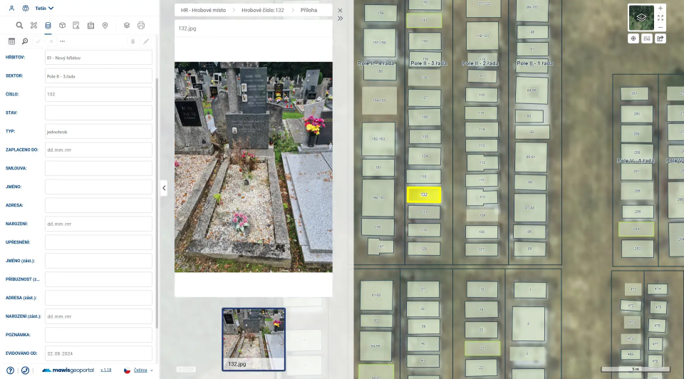
  • What information is recorded in the cemetery and grave site registry?

  • Online map showing the location of graves in one place
  • Photographic documentation and orthophoto map
  • Records of Lease Agreements
  • Information about the deceased, the tenant, the validity of the lease, and reminders regarding non-payment
  • Information on grave availability
  • Additional important information
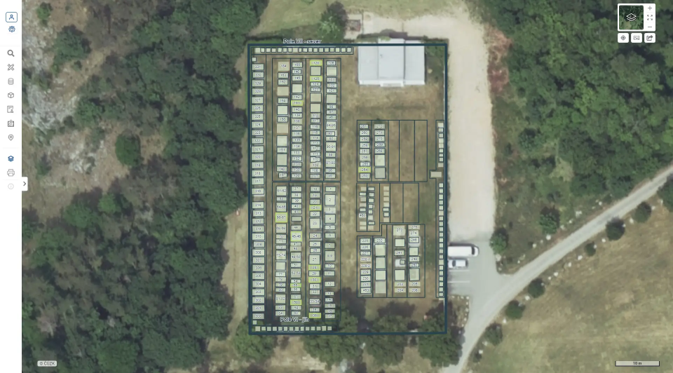
  • We can provide you with the cemetery survey report via the MawisGeoportal mapping application:

  • View of the cemetery, gravesites, and other features
  • Cemetery Management and Record-Keeping of Grave Site Fees
  • Notice of Contract Expiration
  • Views of gravestone photos and orthophoto maps
  • Option to filter items based on selected criteria and export to XLS, SHP, or print
  • Sharing data with colleagues or the public
  • Easy editing and updating of passports
  • Data protection is a given—personal data is hidden from the public
  • Preparation of Lease Agreements
  • What steps will we take to create a cemetery and grave site inventory?

  • We will survey the grave sites and prepare a digital map
  • For field data collection, we will use state-of-the-art methods, including large-scale data collection via laser scanning and photogrammetry [click here for the laser scanning subpage]
  • We will create an orthophoto map of the cemetery
  • We will record information about graves, leaseholders, the deceased, and payments
  • We will number the graves based on the information provided by the Client
  • We will add photos of the headstones, the exact dimensions of the graves, and the type
  • We will transcribe the information from the headstones
  • We will clearly mark which grave sites are available and which are occupied
  • We will add measurements of trees, outdoor furniture, grave walls, and paths
  • We will prepare the data for import into your geographic information database or make it available in the MawisGeoportal mapping application
  • What do we need from you?

  • Specify the area in which the cemetery or cemeteries under your administration are located
  • Documents for grave numbering and information about the deceased and leaseholders
  • Approval of the completed passport
  • The final output is submitted in the following format:

  • SHP map output (GIS format)
  • Tables (XLS, PDF)
  • Cemetery and Grave Site Inventory in the MawisGeoportal App

  • Display of cemetery features and grave sites and their properties
  • Photos
  • Option to filter items based on selected criteria and export to XLS, SHP, or print
  • Maintenance Planning
  • Sharing data with colleagues or the public
  • I can help you with your property inventories

    Miroslava Kubíčková

    Technical Consultant for the MAWIS Portal

    Oops! We could not locate your form.