aktuality_do_mailuarrow-backarrow-bottomauthorbasketbezbarierove_mestoblockquotebtn-arrow-backbtn-arrowcalendarcheckcheckedclosedigitalni_evidencedopravni_znaceniemailfacebookfaqfb-circlefooter-imghousehrbitovinfointuitivni_ovladanikatastralni_datalarge-arrow-bottomlinklinkedin-sidebarlinkedinlist-arrowlockloginmapamistni_komunikacemobiliar_obcemobilni_aplikacemodul_DTMmunicipalitynastaveni_roli_a_spolupracenavrhy_na_vkladnewsletterochrana_obyvatelodeslaniphonepozemkove_upravypresnostprojektantiregcountsearchservice1service2service3service4silne_zabezpeceni_a_dostupnostsmlouvy_na_klikspoluprace_nad_dokumentacispravcistavebnicisubjektysupporttechnicka_infrastrukturatriangle-bottomtrideny_odpadtwitterutilityuzemni_planverejne_osvetleniwebova_aplikaceworkerxingyoutubezadatelzelenzivotni_cyklus_stavbyzivotni_situacezrychleni_vystavby

MawisPasport
greenery

Would you like to get a complete overview of green spaces and other elements of green infrastructure? A green space inventory is an important tool for the effective management of public spaces and for maintenance planning.  

Please contact us; we will prepare a comprehensive green space inventory for you, including an arboricultural assessment, dendrometric data, and taxonomic classification.

The Green Space Inventory is a registry and database of all public green space elements. It provides an overview of trees, shrubs, lawns, flower beds, and other related elements.

Legislation: Under the Civil Code, property owners are required to care for the trees on their land; this also applies to municipalities and their land—particularly with regard to preventing threats to life and property. The obligations of owners and procedures for protecting trees near roads are set forth in the Road Act (Section 35), which requires the implementation of necessary measures to eliminate sources of danger.

Why is it important to have a green passport?

  • A comprehensive overview of the condition and distribution of greenery – simplifies maintenance planning and reduces costs
  • An important resource for the maintenance, restoration, or development of green spaces and environmental protection
  • It helps with budgeting the costs of landscaping maintenance—areas to be mowed, shrubbery areas, hedge lengths, lawn slopes, etc.
  • Ensuring safety in the community (falling trees)
  • For responsible land management in the municipality (reducing temperatures in the municipality, water retention, etc.)
  • Basis for grants and other decisions
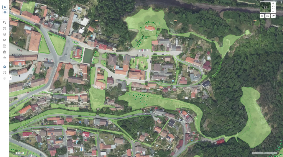
  • What information is recorded in the green space inventory?

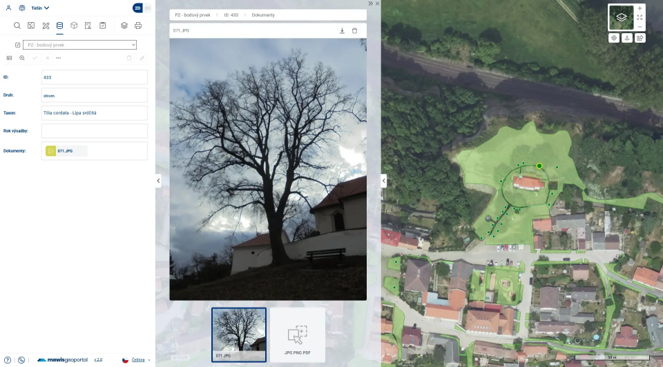
    Trees: taxon, type (coniferous/deciduous), status (standing/felled), owner (city/private), notes, area, photo, trunk circumference/diameter, crown radius, crown base height, tree height, center of gravity deviation, health status, vitality, physiological age, outlook, safety (stability), crown damage, trunk damage, base damage, crown loss, urgency of action, type of action, and other dendrological attributes 

    Shrubs: type (deciduous/coniferous), owner (city/private), area, note, region, taxon=species 

    Mobile greenery (planters): container type (concrete, round, etc.), owner (city/private), notes, area 

    Stands (groups): type (group of trees/group of woody plants), owner (city/private), area, notes, region 

    Grass areas: lawn type, slope gradient (flat/steep/gentle), owner (city/private), area, notes, location 

    Flower beds: type of bed (perennials, annuals, roses), owner (city/private), area, notes, location 

    How will we go about creating a green space inventory?

  • We will conduct a geodetic survey of trees, shrubs, lawns, and all other infrastructure elements, and professionally determine the necessary dendrological attributes of each element (complete inventory)
  • If there is a large amount of greenery, we can carry out the inventory in several phases
  • We will then process this collected data into a green space inventory using a GIS tool in accordance with current standards
  • We will then provide you with the data in a GIS format (SHP format) or display it for you in our web-based map viewer, MawisGeoportal.
  • The final output is submitted in the following format:

  • SHP map output (GIS format)
  • Tables (XLS, PDF)
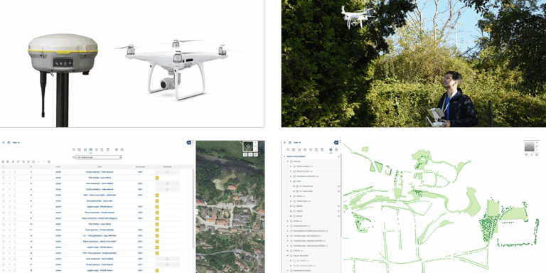
  • Green Space Inventory in the MawisGeoportal App

  • Display of green space inventory items and their properties
  • Photos
  • Option to filter items based on selected criteria and export to XLS, SHP, or print
  • Maintenance Planning
  • Sharing data with colleagues or the public
  • I can help you with your property inventories

    Miroslava Kubíčková

    Technical Consultant for the MAWIS Portal

    Oops! We could not locate your form.